Geovisualization Targets For Virtual Plasencia
[/lab_heading]
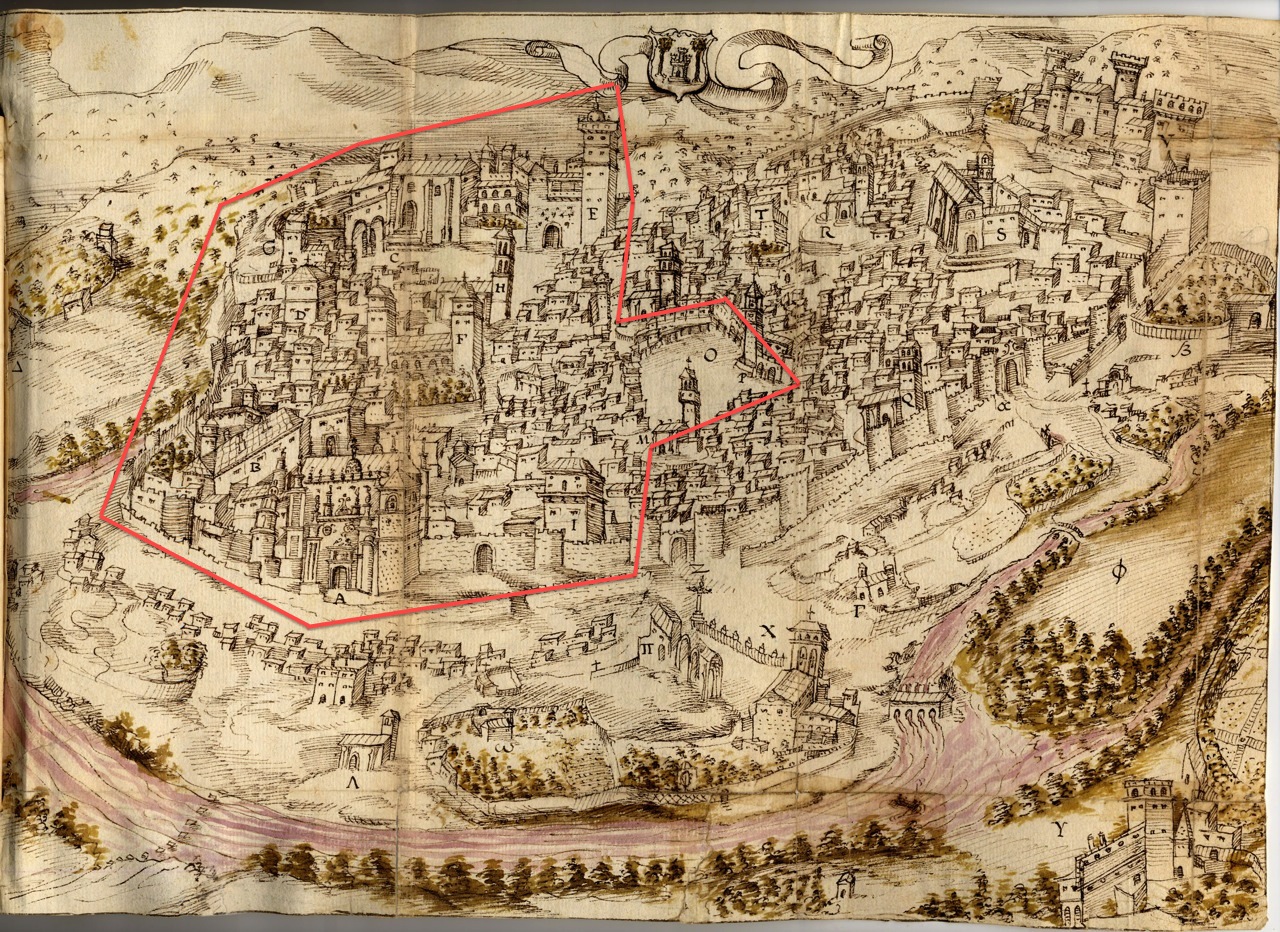
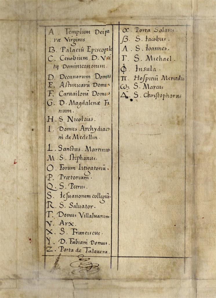
The project will begin the deliberate steps of designing the 3D environment and buildings in Virtual Plasencia. Specifically, for this discrete project we will model several sections of the walled city of Plasencia, which include a limited number of prominent streets/pathways, public spaces, prominent buildings, and individual residences/family compounds. We have targeted this specific section of the city (approximately 30 percent of the walled city) because it is the focus of first 100 pages ofBook One of the Capitulary Acts. This 30 percent corresponds to the portion of the city located west of the Plaza Mayor (noted as “O” on the map below). (See red-encircled section of the map of sixteenth century Plasencia. Ms. 2650. Biblioteca y Archivo de la Universidad de Salamanca.) The remainder of the city, as well as more extensive details, will be modeled with subsequent funding from other grant-making institutions.
[/lab_scroll_box]

16th Century Map of Plasencia
Ms. 2650. Biblioteca y Archivo de la Universidad de Salamanca. For academic research and non-profit educational purposes only, per Title 7 of the United States Code. This image shall not be reproduced. The original document is the property of the Biblioteca y Archivo de la Universidad de Salamanca. Para fines de investigación y educación sin fines de lucro académicos solamente, por el Título 7 del Código de los Estados Unidos. Esta imagen no se reproducirá. El documento original es propiedad de Biblioteca y Archivo de la Universidad de Salamanca.

Ms. 2650. Biblioteca y Archivo de la Universidad de Salamanca. For academic research and non-profit educational purposes only, per Title 7 of the United States Code. This image shall not be reproduced. The original document is the property of the Biblioteca y Archivo de la Universidad de Salamanca. Para fines de investigación y educación sin fines de lucro académicos solamente, por el Título 7 del Código de los Estados Unidos. Esta imagen no se reproducirá. El documento original es propiedad de Biblioteca y Archivo de la Universidad de Salamanca.
For this discrete project we will model the following geographic features:
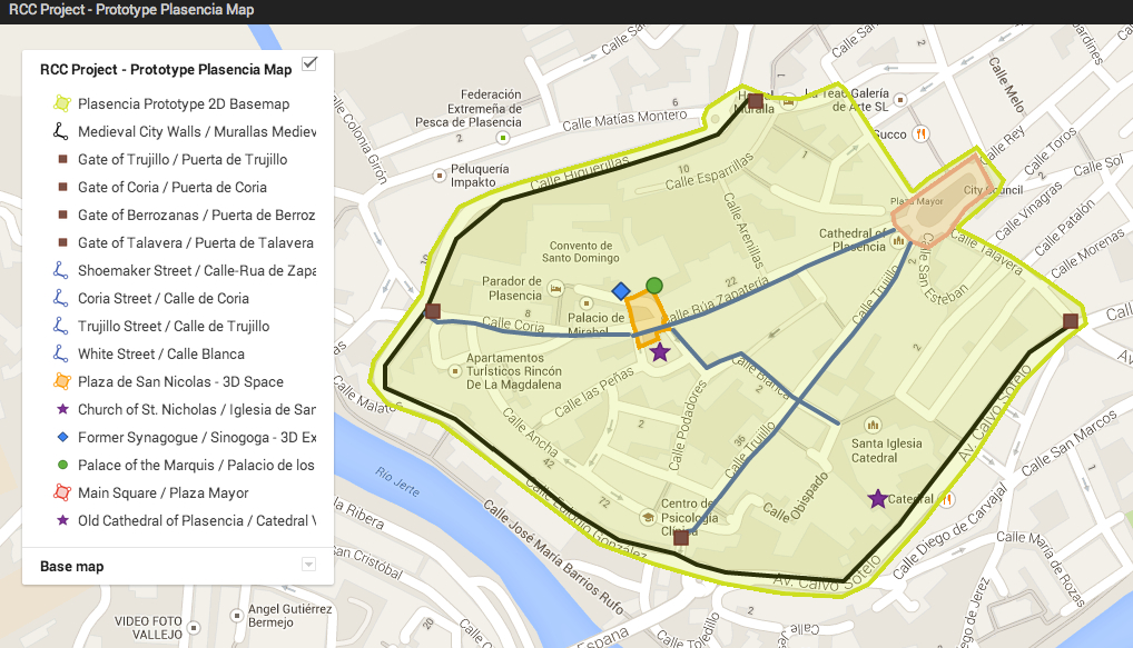
- The base streets and foot pathways map for the walled section of the city that is bounded by the Plaza Mayor (east), the Puerta de Trujillo (south), the Puerta de Coria (west), and the Puerta de Berrozanas (north). This includes:
- 25 base street and footpath streets: Calle Talavera, Calle Contador, Call Sta. Maria, Calle Encarnacion, Calle St. Esteban, Calle Sta. Clara, Calle Blanca, Calle Obispo, Calle Trujillo, Calle Peligros, Calle Ancha, Calle La Salud, Calle Domingo el Viejo, Calle Calderos, Calle Penas, Calle Podadores, Calle Sta. Isabel, Calle La Veras, Calle Coria, Calle San Vicente, Calle Arenillas, Calle Esparrillas, Calle Resbaladero, Calle Berrozanas, and Calle de los Quesos.
- Detailed 3D modeling of two principal streets.
- Calle/Rua de Zapateria and Calle Trujillo
- Detailed 3D modeling of the exterior and interior of one city gate that facilitates access into and out of the walled city.
- Puerta de Trujillo
- Detailed 3D modeling of the exterior and interior of two public spaces.
- Plaza de la Catedral and Plaza de San Nicolas
- Detailed 3D modeling of the exterior and interior of one major building.
- Catedral Vieja, Sinogoga/Monaseterio de San Vicente Ferrer, Iglesia de San Nicolas
With time and budget permitting, we will model these additional geographic features:
- Detailed 3D modeling of four principal streets.
- Calle Coria, Calle Talavera, Calle Ancha, and Calle de Berrozanas
- Detailed 3D modeling of the exterior and interior of four city gates that facilitate access into and out of the walled city.
- Puerta de Talavera, Puerta de Coria, and Puerta de Berrozanas
- Detailed 3D modeling of the exterior and interior of two public spaces.
- Plaza Mayor and Plaza Ansano
- Detailed 3D modeling of the exterior and interior of two major buildings.
- Sinogoga/Monaseterio de San Vicente Ferrer and Iglesia de San Nicolas
- Detailed 3D modeling of the exterior of 13 individual buildings/residences/family compounds.
- Apartamento de la Mota, Iglesia de San Martin, Convento de Sta. Clara, Fuente de Cabildo, Casa del Dean, Casa de Dos Torres, Casa de Bernardino Carvajal, Palacio de Mirabel (Zuniga), Palacio Carvajal y Giron, Casa de Almaraz, Casa de los Vargas, Casa de Hernando de Carvajal, and Convento de Clarisas
[/lab_scroll_box]
